 Catalogue PIGMA
/Human Activities/Industrial Fishing
Type of resources
Available actions
Topics
Keywords
Contact for the resource
Provided by
Years
Formats
Representation types
Update frequencies
status
Scale
Resolution
-
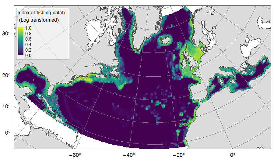
Distribution of catch from deep-sea impacting fishing on the North Atlantic (18°N to 76°N and 36°E to 98°W), for the period 2010-2015. The average of yearly fishing catch for the period 2010-2015 is displayed as an index on the ATLAS grid of 25km * 25km resolution. Source data originated from the Global Fisheries Landings V4.0 database. The dataset was filtered to select only the fishing gears that have an impact on large areas of the seafloor (dredges, bottom trawls, and Danish seines). Within each cell, all remaining catch records were summed to get the total catch rate of the considered year. This dataset was built to feed a basin-wide spatial conservation planning exercise, targeting the deep sea of the North Atlantic. The goal of this approach was to identify conservation priority areas for Vulnerable Marine Ecosystems (VMEs) and deep fish species, based on the distribution of species and habitats, human activities and current spatial management.
-

The repository of commercially exploited species of interest in the Fisheries Information System is based on the FAO's ASFIS repository enriched with species of high commercial interest in France (metropolitan and overseas).
-

Size-weight relationships are specific to each scientific species and its environment. They allow the size of an individual to be determined from its weight or vice versa. These relationships are established statistically from a sample of individuals representative of the species.
-

The MFSP repository of the Fisheries Information System corresponds to the combination of Parameters, Supports, Fractions, Methods and Units. It allows variables to be entered, banked and retrieved. It is associated with many other repositories: species, gear, etc.
-

For some commercial species, coefficients called live weight equivalents allow the live weight of the fish to be calculated from the weight recorded on landing, or from the net weight of the various processed products prepared on board or in factories located on the coast.
-

The gear repository of the Fisheries Information System includes, on the one hand, the FAO fishing gears enriched with national specificities and, on the other hand, the sampling gears used during the fisheries surveys conducted by Ifremer and its partners.
-

The repository of location in the Fisheries Information System is divided into 3 categories: places on land, areas at sea and regulatory areas at sea. Each of these is organised hierarchically. There are 93 levels of places in Harmonie: a metadata sheet exists for each of them with, when it exists, a geographical layer.
-

The scientific species repository of the Fisheries Information System lists the species observed during fishing campaigns or within the framework of the observations of collection programmes (ObsVentes, ObsMer, Campaigns, etc.).
-

A metier in the Fisheries Information System is a fishing practice defined by a fishing gear and a target species. They are used for statistical purposes to evaluate fishing strategies and efforts.
-

The GRSF, the Global Record of Stocks and Fisheries, integrates data from three authoritative sources: FIRMS (Fisheries and Resources Monitoring System), RAM (RAM Legacy Stock Assessment Database) and FishSource (Program of the Sustainable Fisheries Partnership). The GRSF content disseminated through this catalogue is distributed to test the logic to generate unique identifiers and review collated stock and fishery data. This beta release can contain errors and we welcome feedback on content and software performance, as well as the overall usability. Beta users are advised to use caution and to not rely in any way on the application and/or trust content and accompanying materials. What is the GRSF? A comprehensive and transparent inventory of stocks and fisheries records across multiple data providers.